

The drive up to the Alpine Ridge Trail is an adventure. If you begin on the East side of Rocky Mountain National Park, you have the choice of driving up Old Fall River Road or Trail Ridge Road. Both routes are inside of Rocky Mountain National Park, so you need to purchase a park pass.
Old Fall River Road
We opted for the Old Fall River Road route where you can go one-way, and that is up. The road begins near the Endovalley picnic area and leads to the Alpine Visitor Center and the Alpine Ridge Trail. The gravel road is eleven miles long. You can expect tight turns and slow speeds. (The speed limit is only 15 mph.) The road is open seasonally and can close at any time for poor weather conditions. It’s a good idea to check the National Park Service’s Road Status Report before heading up. You can avoid crowds and afternoon storms by starting early.
Chasm Falls
One of the highlights along the road is Chasm Falls which is hidden from view. There is a small pull-out with enough room for a handful of cars to park. The trail leading down to the viewing deck is short and steep. If you can find a spot, Chasm Falls is worth stopping for. I included it as one of our best waterfall hikes in Rocky Mountain National Park.

above tree line
Old Fall River Road takes you above the tree line. The views from this road are spectacular. Many times on our journey we have spotted elk. Eventually you connect to the parking lot of the Alpine Visitors Center where parking is competitive.
Alpine visitors center
The Alpine Visitors Center is a great place to use the restroom, shop for souvenirs, take pictures, grab a snack, and ask park rangers any questions you have about the tundra. It’s usually noticeably colder and windier at this altitude, so we add on a layer of clothing before walking around.
If you are looking for a fun and inexpensive activity/souvenir, my girls enjoyed picking out postcards for their friends back home at the gift shop. There is a post office in downtown Estes Park where you can purchase stamps and send them.
Alpine Ridge Trail

I’ve always noticed people hiking up the Alpine Ridge trail, but this was the first time we decided to make the hike up. It helped that we had a warm day with low winds.

The hike is only .3 miles each way. Concrete stairs climb to the top. You start at high elevation and end up at even higher elevation, so even the short distance is a cardio challenge. My 4-year-old was able to make it on her own, but my 2-year-old got to ride on her Dad’s shoulders. I appreciate that the National Park Service places educational signage along the trail to help explain what you are looking at, why you are out of breath, and what they are doing to protect the natural environment surrounding us.
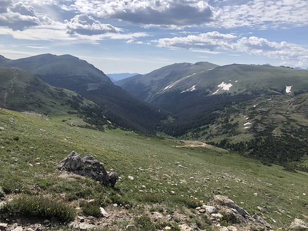
From this perspective, you can see Old Fall River road winding up the mountain.

The wildflowers were blooming on the tundra which is a delicate landscape. This area is roped off to encourage crowds to stay on the path.

There were several groupings of large rocks that my girls enjoyed climbing on.

The elevation at the top is 12,005 ft. above sea level. You can see for miles! I’m happy we took the time to take the small trek up the trail. It was something our whole family enjoyed. If you like this tundra hike, I also recommend reading our post on the Ute Trail.
Trail Ridge Road
We took Trail Ridge Road back down the mountain towards Estes Park. This trail is far less rustic than Old Fall River Road. We enjoyed views of the mountains and spotting a herd of elk playing in the snow.

6 thoughts on “Alpine Ridge Trail”
Comments are closed.